Methodology
Court-defensible cell-site analysis: how validation works
A practical guide for investigators and prosecutors: what carrier CDR and CSLI actually show, where unvalidated analysis breaks down under cross-examination, and how field-measured coverage turns tower records into evidence that holds.
What cell-site analysis is
Every time a phone places a call, sends a message, or moves data, the carrier's network records which cell site — and usually which sector of that site — handled the transaction. Those entries live in call detail records (CDR), and the location-bearing portion of them is cell-site location information (CSLI). Cell-site analysis is the discipline of reading those records against the network's real geography to establish where a device could have been — and, just as importantly, where it could not.
The work comes in two forms. Historical analysis interprets records the network has already generated, and is what most investigations and nearly all courtroom testimony rely on. Prospective collection captures cell-site information going forward under its own legal process. Everything on this page applies to both, because both stand or fall on the same question: how accurately do you know what each sector actually covers?
What the records can — and can't — tell you
A CSLI entry places a device inside a sector's serving area. It does not place the device at a point, at an address, or even reliably near the tower. Three realities of radio networks decide how much a record is really worth:
- A serving area is not a circle or a pie wedge. Its true shape is set by antenna azimuth, height, transmit power, terrain, buildings, and network load — and it can reach much farther, or much less far, than a drawn radius suggests.
- Phones do not always use the nearest tower. A device attaches to the strongest usable signal, which load balancing, topography, and indoor attenuation routinely hand to a site that is not the closest one. An analysis built on the nearest-tower assumption is an open invitation to impeachment.
- Coverage drifts. Carriers add sites, re-aim sectors, and re-balance networks continuously. A coverage estimate that was right when it was generated can be wrong for the week of your incident.
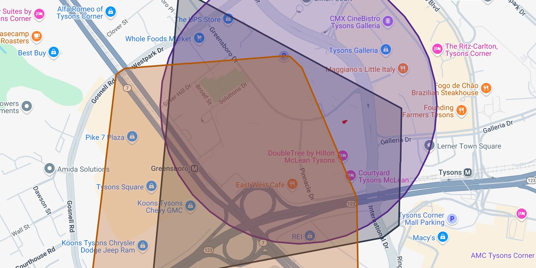
The core problem in one image: ask three data sources which sector serves a given block, and you will routinely get three different answers. Until something independent breaks the tie, an analyst is choosing which unverified estimate to believe.
Why courtrooms push back
Cell-site evidence arrives in court under scrutiny from the start. In the United States, since Carpenter v. United States (2018), obtaining historical CSLI from a carrier generally requires a warrant — so by the time records reach a jury, the defense has had every reason to examine how they were obtained and what was done with them.
The analysis itself then has to survive expert-evidence review. Courts applying the Daubert or Frye standards ask whether a method can be tested, whether its error rate is known, and whether it follows accepted practice. That is precisely where unvalidated cell-site work fails: a coverage footprint that no one measured is an assertion, not a finding. The recurring attacks are predictable —
- overstated precision: testimony that slides from "the sector serving this area" to "the phone was at the house";
- a stale or generic coverage model that does not match the network on the date in question;
- the nearest-tower assumption presented as physics;
- methodology that cannot be reproduced by another analyst from the same records.
None of these are exotic defense theories. They are reasonable questions, and the only durable response is an analysis that answered them before it was challenged.
What validation actually means
Validation is the step that separates a defensible analysis from a colored map: comparing the coverage a record implies against coverage that was measured in the field — real signal measurements, on real streets, showing which sectors actually serve which places. When the estimate and the measurement agree, you can state a serving area with confidence and show your work. When they disagree, you find out before opposing counsel does.
In practice, a defensible cell-site workflow looks like this:
- Acquire lawfully, preserve originals. Obtain records under the proper legal process and keep the carrier's original files untouched alongside every derived product.
- Normalize without altering. Carrier formats differ; converting them for analysis must never change the underlying values, and the conversion itself should be documented.
- Map against measured coverage, dated to the incident. Use serving areas grounded in field measurement — not a bare tower list with drawn radii — and know the vintage of every coverage source you rely on.
- State conclusions with their uncertainty. A serving area, honestly bounded, is powerful evidence. A pin on a map is a promise the data cannot keep.
- Document lineage end to end. Another analyst, given the same records and the same methodology, should reach the same result — that is what makes testimony reproducible rather than personal.
How ATLAS approaches it
ATLAS was built around exactly this workflow. It ingests CDR and CSLI in the formats carriers deliver, maps every record against verified, field-measured coverage, and — where measured data doesn't yet exist for an area — the ATLAS Companion app collects those measurements in the field to close the gap. The result is analysis where the serving areas are grounded in observation, the uncertainty is stated instead of hidden, and the methodology is documented for the courtroom from the first query.
Common questions
Does a phone always connect to the nearest tower?
No. A device attaches to the strongest usable signal, and load balancing, terrain, and building attenuation routinely make that a site other than the closest one. Treating "nearest tower" as a rule is one of the most common — and most successfully challenged — errors in cell-site testimony.
Can CSLI place someone at an exact address?
Not by itself. A record places a device within a sector's serving area. Validated, field-measured coverage can bound that area honestly — often usefully tight, sometimes surprisingly wide — but a single CSLI record is never a GPS point, and presenting it as one invites reversal.
Is a warrant required for historical CSLI?
In the United States, generally yes: under Carpenter v. United States (2018), accessing historical CSLI from a carrier is a Fourth Amendment search. Plan the legal process early — the strength of the analysis never cures a defect in how the records were obtained.
Put validated cell-site analysis on your next case
See the methodology working on coverage in your own operating area.